Note: I will not be posting those pictures on this blog which are copyright protected. To check those pictures you will have to go to the website address given below.

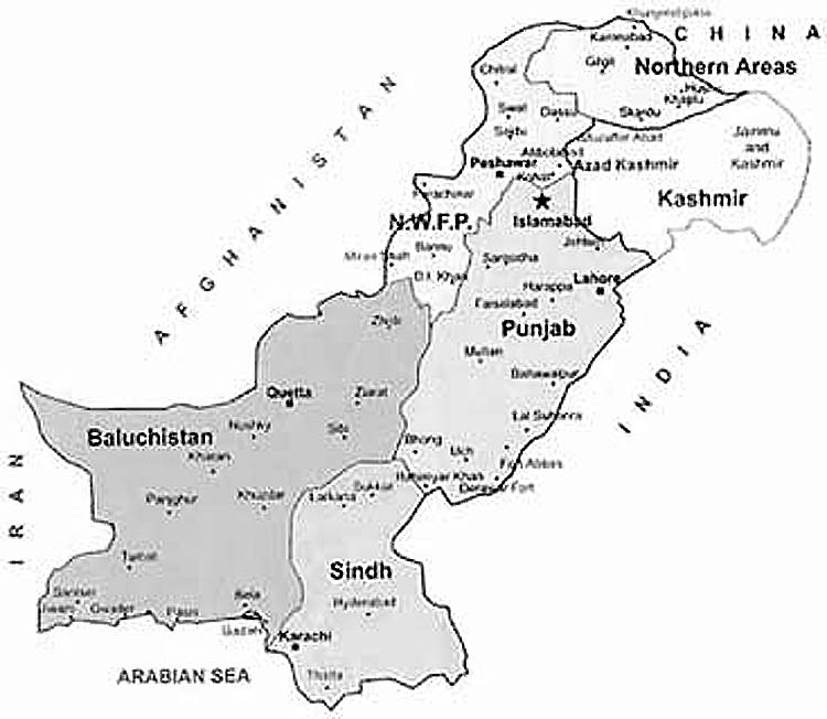
Last time I checked Jammu and Kashmir was a disputed territory and was counted in the flag of Pakistan and India. That is how we are seeing the map of Pakistan from last 65 years. However, this year when 14th august came and I decided to change my face book display picture to Pakistan flag or Map of Pakistan to show ‘how much I love my country’. This is what I saw on almost every Google image.

http://mapsof.net/map/pakistan-flag-map

Aren’t we missing something? Is this the map that we see in our Pakistan Studies book? Check your books again if you have forgotten what the actual map looked like (patriotic Pakistanis). Because that is not how its made on the government of Pakistan website (the most authentic website to represent Pakistan map worldwide).

http://www.pakistan.gov.pk/gop/index.php?q=aHR0cDovLzE5Mi4xNjguNzAuMTM2L2dvcC8%3D
Missing Kashmir from Pakistan map:
It looks like someone has been tempering with the Pakistan map and in turn is implementing a seed of ‘missing Kashmir dilemma’ in young Pakistani’s mind. These young Pakistanis might never know what their map actually looked like.
But the story doesn’t ends here. I decided to search some more and when I searched ‘Indian flag map’ and ‘Indian map’ terms in Google search images, the results that came in front of my eyes were indeed surprising.
Indian version of the map had complete Kashmiri territory included on Indian side of the border. The Jammu and Kashmir were not even presented as disputed (dotted lines) but were looking like part of India.
http://campnfam.com/galleries/india-map-with-states-and-cities-names-i3.jpg
http://www.alpineascents.com/india-map.asp
Online Media – Setting predisposed agenda!
Wikipedia also state that Indian government now controls the jammu and Kashmir state because they held elections in Kashmir in 2008. These elections were stated by the UNHCR commission as ‘free and fair’ and were having 60% voter turnout.
However, what this statement doesn’t justify is that holding elections in a disputed territory by one government does not mean that the authority to govern that disputed territory can be given to that country. The state of Kashmir and Jammu was never free after 1947 and they should be accounted as disputed.
If Indian map holds them as part of their boundary then Pakistan has the equal right to do that with Kashmir.
The Pakistan map Conspiracy:
Now let’s see the real map of Pakistan and how the flag of Pakistan looks on it. Surprisingly some websites admin use their brains. This is the real map of Pakistan with added Kashmir.
http://doctornabeel.com/pakistan-map-flag-image/542/
Disputed area is hidden under the Pakistani flag. All those readers who want to place image of the map of Pakistan as their display picture should use this map.
According to Princeton.edu disputed territories cannot be included in the country boundary and they are separated by an official Line of control from both the states. So, Indian state including Kashmir and Jammu in its map is illegal.
The old and real map of Pakistan including Kashmir:
http://newsletters.ahrchk.net/qaumi/mainfile.php/Map/55/
This is the old map of Pakistan and as you can see a ‘dotted area’ that defines that, the Jammu and Kashmir is a disputed area. This area is not included inside the Pakistani boundaries but as the disputed area is not part of any other country and most likely will be given to Pakistan or India. It must be used as dotted area until then.

Conclusion:
As you can see, the social media or online media is a place where one can learn many new things and can get a lot of information. However, creating conspiracies on social media is also very easy. A person can temper with a picture and post it on social media sites. In addition, those people who do not do research by themselves will think the picture is authentic. As many websites thought that, the map of Pakistan without Kashmir was authentic.
Note to readers:
Do not place map of Pakistan with missing Kashmir on your display pictures or any other place. Those kids who do not know which one is the real map of Pakistan should consult their elders.

